An earthquake with a magnitude of 7.0 struck off the coast of Northern California on Thursday, briefly prompting a tsunami warning and leaving residents rattled from Southern Oregon to the San Joaquin Valley in California.
State and local officials in California were working to assess the full scope of the damage, and early reports appeared to show that the earthquake did not cause major destruction. But it was the strongest to shake the state in more than five years.
Here’s what we know so far.
Where did the earthquake hit?
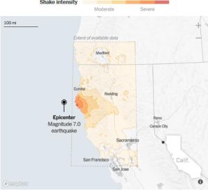
The quake struck about 30 miles off the California coast a little before 11 a.m. local time, about 62 miles southwest of Ferndale, which has a population of about 1,300 people. It hit near a seismically active area known as the Mendocino Triple Junction, where three major tectonic plates meet.

Note: Map shows the area with a shake intensity of 3 or greater, which U.S.G.S. defines as “weak,” though the earthquake may be felt outside the areas shown. Source: U.S.G.S. By William B. Davis and John Keefe
More than a dozen aftershocks were reported after the initial earthquake, including one with a magnitude of 4.3. The aftershocks could continue for weeks, according to the U.S. Geological Survey.
Stephen DeLong, a geologist with the Earthquake Science Center at the U.S.G.S., said in a news briefing on Thursday that those closest to the epicenter, including residents of Ferndale, were the most likely to feel shaking or see any damage.
The quake was the strongest to hit California since July 2019, when an earthquake with a magnitude of 7.1 hit near Ridgecrest in the Mojave Desert.
In the past century, there have been at least 40 earthquakes with a magnitude of 6.0 or greater, including five with a magnitude of 7.0 or greater, that have struck within about 150 miles from Thursday’s quake, according to the U.S.G.S.
What were the impacts?
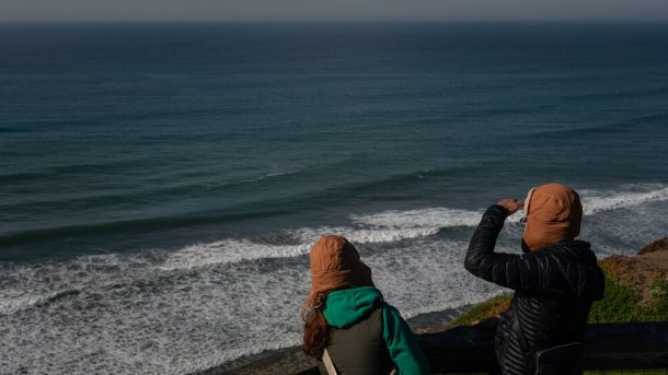
The earthquake prompted the National Weather Service to issue a brief tsunami warning, urging those near coastal areas in Northern California and southern Oregon to move inland or seek higher ground. But the warning was canceled about an hour after the temblor struck.
Bay Area Rapid Transit, which serves the San Francisco Bay Area, temporarily suspended some of its service, and some classes were canceled.
But overall the impacts were largely minimal, with minor damage in areas closest to the epicenter. Some shops in the area reported groceries toppling from shelves and shattered bottles. Across the West Coast, many residents felt the shaking, and some evacuated to higher ground.
Within hours of the earthquake, the U.S.G.S. said it had received reports from more than 14,000 people, from as far north as Salem, Ore., and as far south as the San Joaquin Valley.
In Humboldt County, Calif., which includes the city of Ferndale, about 10,000 customers were without power after the earthquake, according to poweroutage.us, which tracks outages. Power was largely restored within hours, with fewer than 500 customers without power in the county later in the day.
Why was there a tsunami warning?
Tsunami warnings are normally issued when there has been a coastal earthquake of a magnitude of 6.5 or greater for the U.S., Canadian Atlantic and Gulf coasts, according to the National Oceanic and Atmospheric Administration, which runs the Weather Service.
Dave Snider, a tsunami warning coordinator at NOAA, said it was typical for a broad alert to be issued initially before it was refined or rolled back once more details about an earthquake emerged.
The area where Thursday’s temblor struck is a complex meeting point of tectonic plates where earthquakes are unpredictable, said Christine Goulet, the director of the Earthquake Science Center. In some cases, quakes here can cause vertical thrusts that drive tsunamis.
“You have all those forces pulling and twisting in all directions,” Dr. Goulet said. She was not involved in sending out the warning, but said it was very likely issued out of an abundance of caution.
Gov. Gavin Newsom of California added on Thursday that it was state protocol to issue tsunami warnings whenever a quake with a magnitude of more than 5.0 struck in a coastal region.
Why wasn’t there more damage?
Dr. DeLong said the earthquake was a “largely horizontal motion,” meaning that two faults had slid past each other. It was also not particularly deep, and it struck offshore.
“If the earthquake happens farther away, there’s less shaking,” Dr. DeLong said at the news briefing, adding, “We just don’t anticipate the humanitarian effects that we see from these earthquakes that occur under the land.”
Robert de Groot, an operations team leader for the U.S.G.S.’s ShakeAlert system, which detects earthquakes, described the motion of the quake as akin to slicing a cup of water with a knife.
“Nothing really moves,” he said. “The knife just goes through.”
Still, the earthquake struck during what experts said could be a period of increased seismic activity in the state, after decades of relative quiet. Seismologists have long warned that an overdue “Big One,” which California has not experienced since 1906, could happen at any point.


